Polar Data Cube v1.0.1#
How to open this dataset in DeepESDL JupyterLab#
from xcube.core.store import new_data_store
store = new_data_store("s3", root="deep-esdl-public", storage_options=dict(anon=True))
ds = store.open_data('polar-100m-1x2048x2048-1.0.1.zarr')
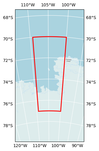
Bounding box map#
Map tiles and data from OpenStreetMap, under the ODbL.
Basic information#
| Parameter | Value |
|---|---|
| Bounding box longitude (°) | -109.3 to -100 |
| Bounding box latitude (°) | -70 to -77 |
| Time range | 2013-01-01 to 2017-01-01 |
| Time period | 1461D |
| Publisher | DeepESDL Team |
Click here for full dataset metadata.
Variable list#
Click on a variable name to jump to the variable’s full metadata.
| Variable | Long name | Units |
|---|---|---|
| curie_depth_200km | Curie Depth Estimates 200x200 km | m |
| curie_depth_300km | Curie Depth Estimates 300x300 km | m |
| geothermal_heat_flow_200km | Geothermal Heat Flow 200x200 km | m |
| geothermal_heat_flow_300km | Geothermal Heat Flow 300x300 km | m |
| geothermal_heat_flow_uncertainty_200km | Geothermal Heat Flow Uncertainty 200x200 km | m |
| geothermal_heat_flow_uncertainty_300km | Geothermal Heat Flow Uncertainty 300x300 km | m |
| ice_thickness | Ice Thickness | m |
| magnetic_anomaly | Magnetic Anomaly | nT |
| thw_124 | Subglacial Lake Thw 124 | 1 |
| thw_142 | Subglacial Lake Thw 142 | 1 |
| thw_170 | Subglacial Lake Thw 170 | 1 |
| thw_70 | Subglacial Lake Thw 70 | 1 |
Full variable metadata#
crs#
| Field | Value |
|---|---|
| crs_wkt | PROJCS["WGS 84 / Antarctic Polar Stereographic",GEOGCS["WGS 84",DATUM["WGS_1984",SPHEROID["WGS 84",6378137,298.257223563,AUTHORITY["EPSG","7030"]],AUTHORITY["EPSG","6326"]],PRIMEM["Greenwich",0,AUTHORITY["EPSG","8901"]],UNIT["degree",0.0174532925199433,AUTHORITY["EPSG","9122"]],AUTHORITY["EPSG","4326"]],PROJECTION["Polar_Stereographic"],PARAMETER["latitude_of_origin",-71],PARAMETER["central_meridian",0],PARAMETER["false_easting",0],PARAMETER["false_northing",0],UNIT["metre",1,AUTHORITY["EPSG","9001"]],AXIS["Easting",NORTH],AXIS["Northing",NORTH],AUTHORITY["EPSG","3031"]] |
| false_easting | 0.0 |
| false_northing | 0.0 |
| geographic_crs_name | WGS 84 |
| grid_mapping_name | polar_stereographic |
| horizontal_datum_name | World Geodetic System 1984 |
| inverse_flattening | 298.257223563 |
| longitude_of_prime_meridian | 0.0 |
| prime_meridian_name | Greenwich |
| projected_crs_name | WGS 84 / Antarctic Polar Stereographic |
| reference_ellipsoid_name | WGS 84 |
| semi_major_axis | 6378137.0 |
| semi_minor_axis | 6356752.314245179 |
| spatial_ref | PROJCS["WGS 84 / Antarctic Polar Stereographic",GEOGCS["WGS 84",DATUM["WGS_1984",SPHEROID["WGS 84",6378137,298.257223563,AUTHORITY["EPSG","7030"]],AUTHORITY["EPSG","6326"]],PRIMEM["Greenwich",0,AUTHORITY["EPSG","8901"]],UNIT["degree",0.0174532925199433,AUTHORITY["EPSG","9122"]],AUTHORITY["EPSG","4326"]],PROJECTION["Polar_Stereographic"],PARAMETER["latitude_of_origin",-71],PARAMETER["central_meridian",0],PARAMETER["false_easting",0],PARAMETER["false_northing",0],UNIT["metre",1,AUTHORITY["EPSG","9001"]],AXIS["Easting",NORTH],AXIS["Northing",NORTH],AUTHORITY["EPSG","3031"]] |
| standard_parallel | -71.0 |
| straight_vertical_longitude_from_pole | 0.0 |
curie_depth_200km#
| Field | Value |
|---|---|
| acknowledgement | 4DAntarctica |
| description | Curie depth estimates using a 200x200km window |
| grid_mapping | crs |
| long_name | Curie Depth Estimates 200x200 km |
| original_add_offset | 0.0 |
| original_name | z |
| original_scale_factor | 1.0 |
| processing_steps | Gridding nc dataset, Spatial resampling to 100 m using linear interpolation |
| references | https://doi.org/10.1594/PANGAEA.932452, https://doi.org/10.1038/s43247-021-00242-3 |
| source | https://download.pangaea.de/dataset/932452/files/200km_Dziadek_etal_CurieDepth_Results.nc |
| standard_name | curie_depth_estimates_200km |
| units | m |
curie_depth_300km#
| Field | Value |
|---|---|
| acknowledgement | 4DAntarctica |
| description | Curie depth estimates using a 300x300km window |
| grid_mapping | crs |
| long_name | Curie Depth Estimates 300x300 km |
| original_add_offset | 0.0 |
| original_name | z |
| original_scale_factor | 1.0 |
| processing_steps | Gridding nc dataset, Spatial resampling to 100 m using linear interpolation |
| references | https://doi.org/10.1594/PANGAEA.932452, https://doi.org/10.1038/s43247-021-00242-3 |
| source | https://download.pangaea.de/dataset/932452/files/300km_Dziadek_etal_CurieDepth_Results.nc |
| standard_name | curie_depth_estimates_300km |
| units | m |
geothermal_heat_flow_200km#
| Field | Value |
|---|---|
| acknowledgement | 4DAntarctica |
| description | Geothermal Heat Flow from a 200x200km window |
| grid_mapping | crs |
| long_name | Geothermal Heat Flow 200x200 km |
| original_add_offset | 0.0 |
| original_name | z |
| original_scale_factor | 1.0 |
| processing_steps | Gridding nc dataset, Spatial resampling to 100 m using linear interpolation |
| references | https://doi.org/10.1594/PANGAEA.932452, https://doi.org/10.1038/s43247-021-00242-3 |
| source | https://download.pangaea.de/dataset/932452/files/200km_GHF_windowCenters.nc |
| standard_name | geothermal_heat_flow_200km |
| units | m |
geothermal_heat_flow_300km#
| Field | Value |
|---|---|
| acknowledgement | 4DAntarctica |
| description | Geothermal Heat Flow from a 300x300km window |
| grid_mapping | crs |
| long_name | Geothermal Heat Flow 300x300 km |
| original_add_offset | 0.0 |
| original_name | z |
| original_scale_factor | 1.0 |
| processing_steps | Gridding nc dataset, Spatial resampling to 100 m using linear interpolation |
| references | https://doi.org/10.1594/PANGAEA.932452, https://doi.org/10.1038/s43247-021-00242-3 |
| source | https://download.pangaea.de/dataset/932452/files/300km_GHF_windowCenters.nc |
| standard_name | geothermal_heat_flow_300km |
| units | m |
geothermal_heat_flow_uncertainty_200km#
| Field | Value |
|---|---|
| acknowledgement | 4DAntarctica |
| description | Geothermal Heat Flow Uncertainty from a 200x200km window |
| grid_mapping | crs |
| long_name | Geothermal Heat Flow Uncertainty 200x200 km |
| original_add_offset | 0.0 |
| original_name | z |
| original_scale_factor | 1.0 |
| processing_steps | Gridding nc dataset, Spatial resampling to 100 m using linear interpolation |
| references | https://doi.org/10.1594/PANGAEA.932452, https://doi.org/10.1038/s43247-021-00242-3 |
| source | https://download.pangaea.de/dataset/932452/files/200km_GHF_uncertainty.nc |
| standard_name | geothermal_heat_flow_uncertainty_200km |
| units | m |
geothermal_heat_flow_uncertainty_300km#
| Field | Value |
|---|---|
| acknowledgement | 4DAntarctica |
| description | Geothermal Heat Flow Uncertainty from a 300x300km window |
| grid_mapping | crs |
| long_name | Geothermal Heat Flow Uncertainty 300x300 km |
| original_add_offset | 0.0 |
| original_name | z |
| original_scale_factor | 1.0 |
| processing_steps | Gridding nc dataset, Spatial resampling to 100 m using linear interpolation |
| references | https://doi.org/10.1594/PANGAEA.932452, https://doi.org/10.1038/s43247-021-00242-3 |
| source | https://download.pangaea.de/dataset/932452/files/300km_GHF_uncertainty.nc |
| standard_name | geothermal_heat_flow_uncertainty_300km |
| units | m |
ice_thickness#
| Field | Value |
|---|---|
| acknowledgement | CryoSMOS |
| description | Ice Thickness |
| long_name | Ice Thickness |
| original_add_offset | 0.0 |
| original_name | est |
| original_scale_factor | 1.0 |
| processing_steps | Masking out no-data values, Slicing dataset to the polar region (< -60 degrees), Reprojecting to EPSG:3031, Spatial resampling to 100 m using linear interpolation |
| references | https://opensciencedata.esa.int/products/bedrock-topography-antarctica-cryosmos, http://www.ifac.cnr.it/cryosmos/products/CryoSMOS_D8_EDUM_V2.0.pdf |
| source | http://www.ifac.cnr.it/cryosmos/products/SMOS_IceThickness_2015_300.nc |
| standard_name | ice_thickness |
| units | m |
magnetic_anomaly#
| Field | Value |
|---|---|
| acknowledgement | 4DAntarctica |
| description | Magnetic Anomaly |
| long_name | Magnetic Anomaly |
| original_add_offset | 0.0 |
| original_name | |
| original_scale_factor | 1.0 |
| processing_steps | Spatial resampling to 100 m using linear interpolation |
| references | https://doi.org/10.1594/PANGAEA.932452, https://doi.org/10.1038/s43247-021-00242-3 |
| source | https://download.pangaea.de/dataset/932452/files/ASE_MagneticCompilation_Dziadeketal_250m.tif |
| standard_name | magnetic_anomaly |
| units | nT |
thw_124#
| Field | Value |
|---|---|
| acknowledgement | 4DAntarctica |
| color_bar_name | GnBu |
| description | Subglacial Lake Thw 124 |
| grid_mapping | crs |
| long_name | Subglacial Lake Thw 124 |
| original_add_offset | 0.0 |
| original_name | |
| original_scale_factor | 1.0 |
| processing_steps | Spatial resampling to 100 m using nearest neighbor |
| references | https://doi.org/10.1029/2020GL089658 |
| source | https://4d-antarctica.org/wp-content/uploads/2021/01/Malczyk_etal_2020_data_v2.tar |
| standard_name | thw_124 |
| time_coverage_end | 2017-01-01 |
| time_coverage_start | 2013-01-01 |
| units | 1 |
thw_142#
| Field | Value |
|---|---|
| acknowledgement | 4DAntarctica |
| color_bar_name | GnBu |
| description | Subglacial Lake Thw 142 |
| grid_mapping | crs |
| long_name | Subglacial Lake Thw 142 |
| original_add_offset | 0.0 |
| original_name | |
| original_scale_factor | 1.0 |
| processing_steps | Spatial resampling to 100 m using nearest neighbor |
| references | https://doi.org/10.1029/2020GL089658 |
| source | https://4d-antarctica.org/wp-content/uploads/2021/01/Malczyk_etal_2020_data_v2.tar |
| standard_name | thw_142 |
| time_coverage_end | 2017-01-01 |
| time_coverage_start | 2013-01-01 |
| units | 1 |
thw_170#
| Field | Value |
|---|---|
| acknowledgement | 4DAntarctica |
| color_bar_name | GnBu |
| description | Subglacial Lake Thw 170 |
| grid_mapping | crs |
| long_name | Subglacial Lake Thw 170 |
| original_add_offset | 0.0 |
| original_name | |
| original_scale_factor | 1.0 |
| processing_steps | Spatial resampling to 100 m using nearest neighbor |
| references | https://doi.org/10.1029/2020GL089658 |
| source | https://4d-antarctica.org/wp-content/uploads/2021/01/Malczyk_etal_2020_data_v2.tar |
| standard_name | thw_170 |
| time_coverage_end | 2017-01-01 |
| time_coverage_start | 2013-01-01 |
| units | 1 |
thw_70#
| Field | Value |
|---|---|
| acknowledgement | 4DAntarctica |
| color_bar_name | GnBu |
| description | Subglacial Lake Thw 70 |
| grid_mapping | crs |
| long_name | Subglacial Lake Thw 70 |
| original_add_offset | 0.0 |
| original_name | |
| original_scale_factor | 1.0 |
| processing_steps | Spatial resampling to 100 m using nearest neighbor |
| references | https://doi.org/10.1029/2020GL089658 |
| source | https://4d-antarctica.org/wp-content/uploads/2021/01/Malczyk_etal_2020_data_v2.tar |
| standard_name | thw_70 |
| time_coverage_end | 2017-01-01 |
| time_coverage_start | 2013-01-01 |
| units | 1 |
Full dataset metadata#
| Field | Value |
|---|---|
| Conventions | CF-1.10 |
| acknowledgment | All ESDC data providers are acknowledged inside each variable |
| contributor_name | University of Leipzig, Brockmann Consult GmbH |
| contributor_url | https://www.uni-leipzig.de/, https://www.brockmann-consult.de/ |
| creator_name | University of Leipzig, Brockmann Consult GmbH |
| creator_url | https://www.uni-leipzig.de/, https://www.brockmann-consult.de/ |
| id | polar-100m-1x2048x2048-1.0.1 |
| license | Terms and conditions of the DeepESDL data distribution |
| project | DeepESDL |
| publisher_name | DeepESDL Team |
| publisher_url | https://www.earthsystemdatalab.net/ |
| spatial_ref | EPSG:3031 |
| time_coverage_end | 2017-01-01 |
| time_coverage_start | 2013-01-01 |
| title | Polar Data Cube v1.0.1 |